
Integrating Drone Mapping, GIS, CAD, and Field Data
In today’s fast-paced land development and infrastructure industries, project success depends on having the right data at the right time. At Strata Design, we’ve embraced a forward-thinking approach that blends cutting-edge technology with boots-on-the-ground expertise. By integrating drone mapping, GIS (Geographic Information Systems), CAD modeling, and real-time field data, we help our clients make smarter decisions—faster.
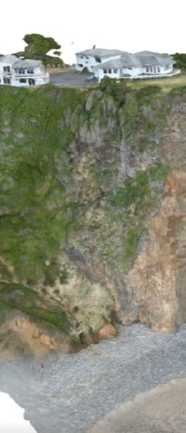
Whether it’s a housing development in a challenging terrain or a utility corridor through forested hills, our hybrid approach creates clarity where there is complexity.
Precision from the Sky: Drone Mapping
Drone mapping is more than just impressive imagery—it's high-resolution, geo-accurate data that provides essential insights at every project stage. Our licensed drone pilots collect:
Topographic surveys with centimeter-level accuracy
3D surface models for volume calculations and slope analysis
Progress monitoring imagery for site development and reporting
These aerial views eliminate guesswork, help identify constraints early, and reduce costly surprises.
Smart Spatial Analysis with GIS
We pair our drone data with GIS tools to provide a deeper, location-based perspective. By layering spatial data—like flood zones, zoning overlays, soil types, and historical land use—we uncover patterns and risks that might otherwise go unnoticed.
Clients use our GIS deliverables to:
Optimize site layouts
Plan for environmental compliance
Prioritize areas for further investigation or testing
Communicate findings visually with stakeholders and permitting agencies
CAD-Ready, Decision-Ready
Bringing field data and drone outputs into CAD platforms allows our engineers to rapidly convert site intelligence into actionable design documents. We produce:
Grading and drainage plans based on accurate contours
Cross-sections and profiles for cut/fill calculations
Digital terrain models for preliminary and final design phases
By keeping this process streamlined and in-house, Strata Design reduces turnaround times and increases collaboration between disciplines.
Ground Truth Matters: Field Data Integration
Technology is powerful, but nothing replaces field experience. Our team collects soil samples, performs borings, probes groundwater levels, and logs subsurface conditions across project sites. That ground-truth data feeds back into our GIS and CAD workflows, tying everything together.
With this fully integrated data model, we can:
Recommend optimal foundation systems
Identify unsuitable fill areas or potential geohazards
Model slope stability and erosion risks with greater accuracy
Real Benefits for Real Projects
By combining drone mapping, GIS, CAD, and geotechnical field data, our clients see:
✅ Reduced permitting delays
✅ Fewer construction changes
✅ Lowered risk during design and construction
✅ Better coordination with planners, architects, and civil engineers
Whether you're working on a subdivision, transportation corridor, commercial facility, or critical infrastructure, our approach keeps your project on solid ground—literally and figuratively.
Let’s Build Smarter, Together
At Strata Design, we don’t just provide data—we deliver insight. Our integrated workflows are built to help developers, engineers, and agencies visualize, analyze, and act with confidence.
Have a site in mind? Let’s explore it from every angle.